


UAV Forecast for Drone Pilots
4.11.52K Reviews
App Specs
- Version
- 2.13.6
- Updated On
- License
- Free
- Downloads
- 1,000,000+
- Developer
- Good To Forecast
- Categories
- Weather
- Platform
- Android, iOS
Screenshots
 Analysis by AppCompare
Before I head out to fly, I want a quick answer to a recurring question: are the conditions at my location suitable, and is the airspace clear? Checking several separate weather and map tools takes time, and it is easy to miss a detail while switching between them. That is the problem UAV Forecast is meant to simplify. It brings drone-focused weather information together with flight-planning details, so I can make a more informed call before unpacking my gear.
Why a drone-specific forecast helps
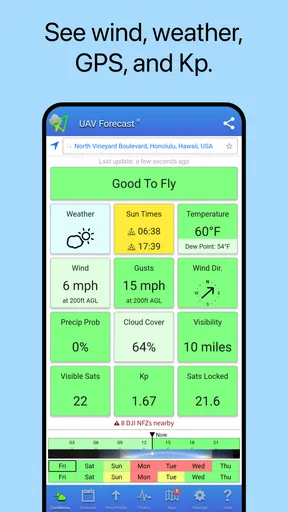
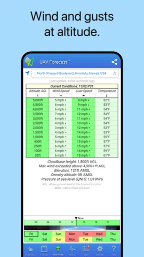
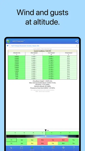
A general weather app can tell me whether rain is expected, but that is only part of the decision. Wind, conditions higher above the ground, and the Kp index can matter to a drone pilot, too. UAV Forecast is built around those concerns, with information including winds aloft, GPS, no-fly zones, and temporary flight restrictions. That focus is its clearest advantage over the usual weather app: it gives me a more relevant starting point for deciding whether to fly.
I still treat a forecast as a planning aid, not permission to take off or a guarantee that conditions will stay safe. A green-looking summary cannot account for every gust, local obstacle, or change in the airspace. I use the app to spot reasons to pause and to choose when to check more carefully, then apply my own judgment and follow the rules that apply where I am flying.
Getting Started with UAV Forecast
First things first, downloading UAV Forecast was a breeze. Available on both Android and iOS, this app doesn’t take up much space, which is a relief if your phone is as cluttered as mine. Once installed, you’re greeted with a straightforward interface that doesn’t require a Ph.D. to navigate. A big thumbs up for user-friendliness!
Making the first check useful
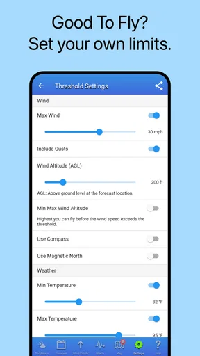
Rather than relying on a broad impression of the forecast, I would start by setting safety limits that make sense for the drone and the way I fly. Those limits are personal: a small camera drone on a calm, open field is not the same as a heavier aircraft carrying a load or operating near buildings. The app can give a simple go-or-no-go indication based on configured conditions, but the useful part is choosing sensible thresholds. A reassuring status is only as meaningful as the settings behind it.
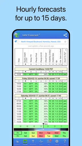
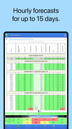
Location is another detail worth checking before trusting the result. If I am travelling, I want to confirm that the app is assessing the place where I actually plan to launch, not a previous location. I would also look at the forecast by hour rather than making a day-long decision from one glance. This small habit helps me avoid arriving at a site too early or too late for a workable window.
Features That Stand Out
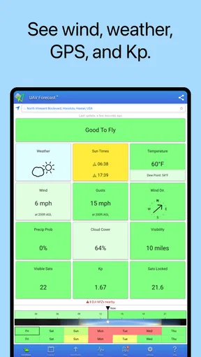
Now, let’s talk features. At its core, UAV Forecast provides detailed weather forecasts tailored for drone pilots. This isn’t your run-of-the-mill weather app. It offers insights into wind speed, temperature, precipitation, and even visibility. But wait, there’s more!
Worth Reading Before You Choose

EA SPORTS FC Mobile 26 Is a Bigger Football Game, but It Takes Time

Flipboard Shows What News Apps Must Do Beyond the Feed

Switching to Android Auto Means Rethinking Your Driving Routine

Google Calendar Makes a Crowded Week Easier to Manage

Ludo King Makes the Most of the Minutes Between Plans

Baby Panda World Brings Quick Play to Modern Phones, but Its Game Library Feels Busy
- Customizable Settings: You can set your own safety limits for wind speed and other conditions. The app then gives you a simple yes or no on whether it’s safe to fly. Super handy!
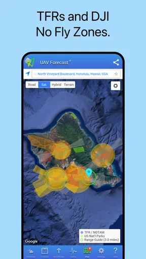
- Satellite Maps: Visualize the area with satellite maps that show no-fly zones and other restricted areas. This feature is a lifesaver for avoiding fines or worse.
- Hourly Forecasts: Plan your flights with precision using hourly updates. This helps in choosing the perfect time for that sunset shot you’ve been dreaming of.
Using the information without over-trusting it
The no-fly-zone and TFR information is especially helpful when I am considering an unfamiliar spot. I can use the map as an early warning to investigate a possible restriction before travelling, instead of discovering an issue at the launch site. Still, I would not treat a map view as the final authority: restrictions can be location-specific and change, so a careful pilot should verify relevant airspace information through the appropriate official channels before flying.
The same cautious approach applies to GPS and the Kp index. They are useful pieces of context in a drone-focused forecast, but they do not replace a check of the aircraft, controller, local surroundings, or applicable guidance. I find the best workflow is to use the app to narrow the question—“is this worth preparing for?”—then make the final call with the full situation in mind.
Real-World Use
So, how does UAV Forecast hold up in the real world? I’ve taken it through its paces over the past few weeks. One of the things that struck me was its accuracy. The wind speed and direction predictions were spot on. I was able to plan my flights around optimal conditions, which meant fewer aborted missions due to unexpected weather changes.
Another aspect I appreciated was the alerts for restricted airspace. As someone who flies in different locations, it’s crucial to stay updated on where you can and can’t go. The app’s map feature ensured I was always informed, saving me from potential headaches.
A practical routine for a day out
Imagine I have a free afternoon and want to capture a short sequence at a field outside my usual area. Before packing, I check the hourly forecast to see whether the wind and other conditions look workable around the time I can arrive. I then inspect the map for airspace concerns and use the result to decide whether the trip deserves more research. If the forecast points to a narrow window, I can shift my arrival time rather than spending the afternoon waiting in poor conditions.
At the site, I would check again before launch. That second look matters because a forecast made earlier is not a live observation of the wind where I am standing. If conditions feel different from what the app suggested, I trust what I can observe and postpone or cancel. The time-saving benefit is not that the app makes every decision for me; it is that it helps me screen plans early and avoid unnecessary setup.
Who benefits most, and who may prefer another tool
This is most useful for pilots who regularly plan flights around weather, travel to different locations, or want wind and airspace considerations in one drone-oriented workflow. It can also help a hobbyist who tends to check conditions only after arriving: a quick forecast beforehand encourages a more deliberate choice about when and where to go.
If you only want to know whether to bring an umbrella, a conventional weather app is simpler and likely all you need. And if your priority is authoritative airspace verification, use the relevant official resources as well; UAV Forecast is a convenient planning companion, not a substitute for those checks. Pilots who rarely fly or always use the same familiar spot may also find that a general forecast plus a separate airspace check is enough.
Where it saves effort—and where it adds friction
Compared with piecing together a general forecast, a map, and drone-specific conditions separately, the app’s main strength is having the flight-planning view in one place. That can reduce the number of checks I need to make before leaving home. The trade-off is that a compact summary can tempt me to treat a complicated decision as a single yes-or-no answer. I get more value by opening the underlying information and understanding what is driving the warning or recommendation.
There can also be a practical delay when information loads, which is frustrating if I am already outside and trying to decide quickly. I would check the forecast before setting off rather than depend on a last-minute lookup. A stronger connection between a quick summary and the details behind it would make the decision process clearer, especially for newer pilots who may not yet know which conditions deserve the most attention.
Cost, availability, and ongoing expectations
UAV Forecast is a free weather app from Good To Forecast, with optional in-app purchases ranging from $1.99 to $119.99 per item. I would begin with the free experience and see whether its planning tools fit my routine before considering any purchase. The app is rated for Everyone, has an average rating of 3.9 from around 17,000 ratings, and has passed 1 million installs. Those figures suggest it has found a sizeable audience, though they do not tell me whether its forecasts will suit every location or flying style.
It was released on November 6, 2015, and version 2.9.40 is the current version. It runs on Android 7.0 or later, and it is also available on iOS. For a practical check, I would confirm that my device can install it and then test the app at the places where I actually fly; a tool is only worthwhile if its information is accessible and useful in my own routine.
Improvements? Just a Few Thoughts
While UAV Forecast has loads of features, there’s always room for improvement. For instance, integrating live chat support would be a neat addition. Sometimes, a quick question requires a quick answer, and having that option would enhance the user experience.
Also, while the app is generally reliable, there were a couple of occasions where the data loaded a bit slowly. This wasn’t a deal-breaker but something to keep in mind if you’re in a hurry to get airborne.
The Verdict
In a nutshell, UAV Forecast for Drone Pilots is an invaluable tool for anyone serious about flying drones. Its detailed weather forecasts and user-friendly interface make it an essential companion for planning your flights. If you’re looking to take your drone flying to the next level, this app is worth every megabyte. Whether you’re a hobbyist or a seasoned pilot, you’ll find it incredibly useful.
So, next time you’re gearing up for a flight, check out UAV Forecast. Trust me, you’ll wonder how you ever flew without it. Safe flying, folks!
Pros
- Accurate weather predictions for flight planning.
- Easy-to-use interface with clear visuals.
- Customizable alerts for specific weather conditions.
- Includes no-fly zone maps for safe operation.
- Works offline after initial data download.
Cons
- Limited free features; subscription needed for full access.
- Occasional GPS accuracy issues.
- Battery usage can be high during extended use.
- Some data requires manual refresh.
- No built-in tutorial for new users.
FAQs for UAV Forecast for Drone Pilots
What features does UAV Forecast offer for drone pilots?
UAV Forecast provides essential features like real-time weather conditions, wind speed, and no-fly zones to ensure safe drone flights. It also includes satellite imagery and GPS signal strength analysis. This app helps pilots plan their flights by offering detailed forecasts up to 7 days in advance, enhancing both safety and efficiency.
Is UAV Forecast available for both Android and iOS devices?
Yes, UAV Forecast is available for download on both Android and iOS platforms. Users can find the app on the Google Play Store for Android devices and the Apple App Store for iOS devices. The app is designed to provide a seamless experience across different operating systems.
How accurate is the weather data provided by UAV Forecast?
UAV Forecast sources its weather data from multiple reliable meteorological services to ensure accuracy. While it provides real-time updates, users should note that weather conditions can change rapidly. It’s always recommended to verify data with local sources, especially when planning critical drone operations.
Does UAV Forecast include information on restricted airspaces?
Yes, UAV Forecast includes information on restricted airspaces, such as no-fly zones near airports, government buildings, and other sensitive areas. This feature is crucial for ensuring compliance with local regulations and avoiding unauthorized or unsafe drone flights. Always check local laws and regulations before flying.
Is there a cost associated with using UAV Forecast?
UAV Forecast offers both free and premium versions. The free version includes basic features like weather updates and wind forecasts. The premium version, available through a subscription, offers advanced features such as extended forecast periods, more detailed satellite imagery, and additional tools for professional drone pilots.


